NASA shares satellite maps showing damage in quake-hit SE Türkiye
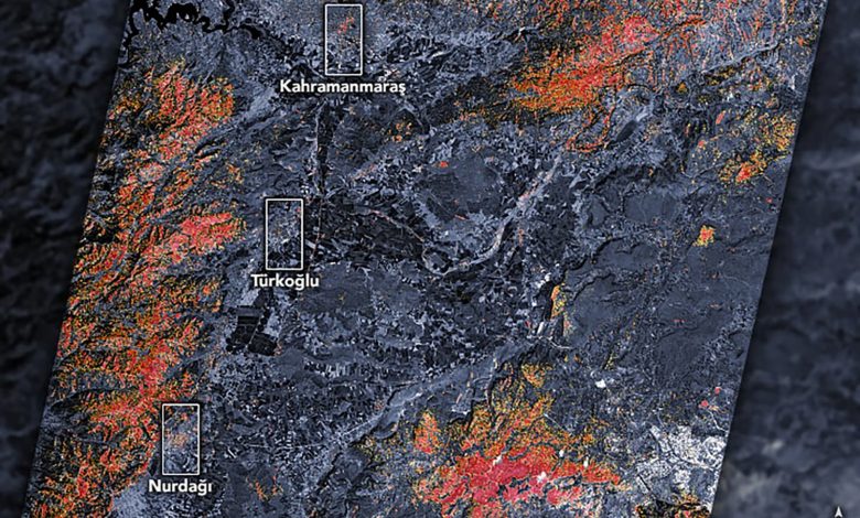

The United States space agency NASA shared satellite maps showing the damage in Kahramanmaraş, its district Türkoğlu and Gaziantep’s Nurdağı that massive Feb. 6 earthquakes have caused in southeastern Türkiye.
“As news of the event spread, scientists at space agencies around the world – including NASA – began processing and analyzing satellite data relevant to the event,” the agency said in statements accompanying the images.
“These were very large and powerful earthquakes that ruptured all the way up to the surface over a long series of fault segments,” Eric Fielding, a geophysicist at NASA’s Jet Propulsion Laboratory, was quoted as saying. He likened the rupture length and magnitude of the quake to the 1906 earthquake that destroyed San Francisco.
The preliminary damage proxy map of NASA showed parts of Türkoğlu, Kahramanmaraş, and Nurdağı, with dark red pixels representing areas likely to have severe damage to buildings, homes, and infrastructure or changes to the landscape, while orange and yellow areas are moderately or partially damaged. Each pixel measures about 30 meters (100 feet) across.
Shanna McClain, the manager of the disasters program area of NASA’s Earth Science Applied Sciences, stated that they were following the event very closely.
McClain emphasized that they have created an earthquake-related mapping portal and are updating this portal as they receive new images and data on the destruction.